
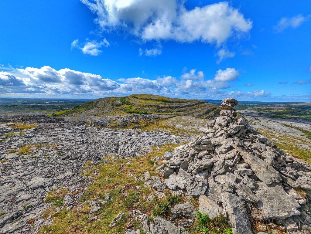
The first time you see the Burren, it stops you cold. Stretching across 250 square kilometers of North Clare, this vast limestone pavement looks like something from another planet—grey stone terraces rippling toward the Atlantic, bare rock split by deep fissures called grykes, and hardly a tree in sight. It’s no wonder Cromwell’s surveyor famously complained there wasn’t enough wood to hang a man, enough water to drown him, or enough earth to bury him.
Watch: the latest film
Where Do the Most Common Irish Surnames Come From?
But get closer, and the Burren reveals itself as one of the most remarkable landscapes in Ireland—a place where geology, botany, archaeology, and sheer beauty collide in ways you won’t find anywhere else.
A Landscape Carved by Ice and Water
The Burren’s story begins 350 million years ago, when this part of Ireland lay beneath a tropical sea. Layer upon layer of marine fossils and sediment compressed into the grey limestone you see today. Fast forward through ice ages, and glaciers scraped the land clean, leaving behind this exposed karst plateau—one of the finest examples in Europe.
Rain did the rest. Over thousands of years, slightly acidic water dissolved the limestone along its natural cracks, widening them into the deep grykes that define the landscape. Between these fissures, the flat limestone blocks—called clints—stretch in geometric patterns that look almost deliberate, like an ancient civilization paved the hillsides.
The result is a terrain that feels otherworldly. Walk the green roads near Carran or hike up the slopes of Mullaghmore, and you’re stepping across 300 million years of visible history. The stone beneath your boots is packed with fossils—ancient corals, crinoids, and shells from that long-vanished sea.
Where Arctic Flowers Meet Mediterranean Blooms
What makes the Burren truly exceptional isn’t just the rock—it’s what grows between the cracks. Sheltered in those deep grykes, protected from wind and grazing animals, thrives one of the most unusual plant communities in Europe. Arctic-alpine species like mountain avens grow alongside Mediterranean flowers like the bloody cranesbill. Spring gentians carpet the ground in May, their intense blue startling against the grey stone.
This botanical paradox happens because the grykes create dozens of microclimates. Deep in the fissures, it stays cool and moist—perfect for Arctic plants that normally grow on high mountains. On sun-baked clint surfaces, conditions suit heat-loving Mediterranean species. Over 70 percent of Ireland’s native flora grows here, in a landscape that looks barren from a distance.
The best time to see this floral show is late spring through early summer, but even in other seasons, the Burren rewards careful observation. Look for the delicate maidenhair fern clinging to shaded grykes, or the hardy mosses and lichens that paint the limestone in subtle colors.
Ancient People Left Their Mark Everywhere
The Burren has drawn people for millennia. More than 70 megalithic tombs dot the landscape, including the magnificent Poulnabrone dolmen—a 6,000-year-old portal tomb balanced on impossibly thin stone legs. Standing beneath its massive capstone, you’re in the presence of Neolithic farmers who somehow thrived in this challenging terrain.
They weren’t the only ones. Ring forts, stone walls, and holy wells scatter across the plateau. The ruins of medieval churches and tower houses tell of later communities who figured out the Burren’s secrets—that the land isn’t barren at all, but requires intimate knowledge to use well. Traditional farmers practiced winterage here, bringing cattle to graze when the porous limestone stays relatively warm and the grass keeps growing long after lowland pastures freeze.
Walk the green roads—ancient pathways used for centuries—and you’re following routes shepherds, traders, and pilgrims wore into the stone. The Burren Way and other marked trails let you experience this history on foot, threading between archaeological sites and natural wonders.
How to Experience the Burren Properly
Start at the Burren Centre in Kilfenora to understand what you’re seeing, then get out and walk. The Burren National Park near Corofin offers marked trails through classic karst landscape, while the area around Fanore on the coast combines limestone pavement with dramatic ocean views.
Hire a local guide if you can—naturalists and archaeologists who’ve spent decades here can show you orchids you’d walk past, point out archaeological features hidden in plain sight, and explain why certain stones have grooves worn by centuries of cattle rubbing.
Visit Aillwee Cave or Doolin Cave to see what happens beneath the surface—massive cavern systems carved by underground rivers, complete with stalactites, stalagmites, and the bones of extinct brown bears. The Great Stalactite in Doolin Cave is over 23 feet long, one of the longest free-hanging stalactites in Europe.
Don’t rush it. The Burren reveals itself slowly. What looks monotonous from a car window becomes endlessly varied on foot. Every season changes it—winter rain darkens the stone to charcoal and fills the temporary lakes called turloughs; spring brings wildflowers; summer offers the longest light for photography; autumn colors the hazel scrub that grows in sheltered valleys.
The Burren isn’t just another pretty Irish landscape. It’s a place where you can touch deep time, where evolution created botanical impossibilities, and where human history stretches back to the Stone Age—all written in grey limestone under vast Clare skies.
Ready to explore more of Ireland’s most stunning places? Download the free guide The Ireland Bucket List: 25 Places That Will Stop You In Your Tracks at irishvideos.com/subscribe, and watch the Love Ireland channel on YouTube at youtube.com/@LoveIreland for videos that bring the Emerald Isle to life.